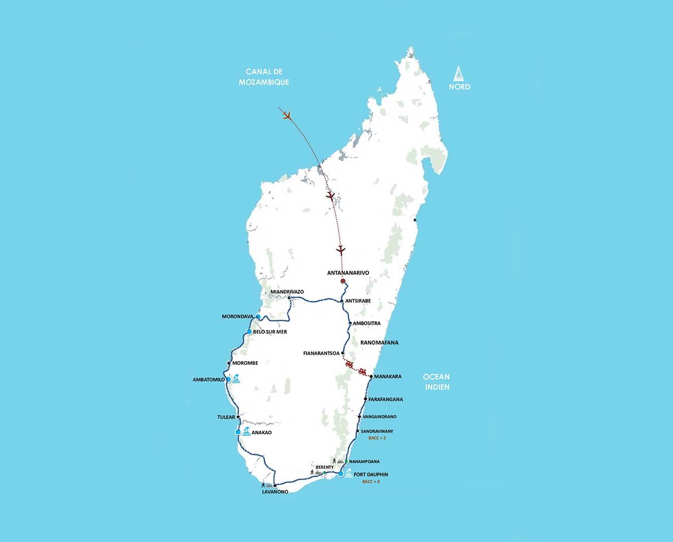
Fly over the deep South to reach the end of the east coast of Madagascar, Tolagnaro the capital of lobster with its annual festival become tradition
City founded in 1643 and named Fort-Dauphin in honor of the king of France Louis XIV.
Endemic fauna and flora specific to the South. (The thorny forest).
Antanosy funerary cultures and daily life of the South.
IMPORTANT : Photos at funerary tombs are not forbidden, but the local population does not like the intrusion, because we enter into their intimacy and their sacredness.
IMPORTANT INFORMATION TO READ CAREFULLY
Climate :
Austral Summer : (November – March) : average 27 years C – 35 years C. Summer coincides with the rainy season from November to March.
Southern winter : (April – October) – 18 season C / 25 season C
Note that the East is very rainy in February and March; little rainy: April – May; scattered rains: June, July, August; best period: September – December.
CHALLENGING circuit that requires an excellent spirit of adaptation.
The spirit of adventure is absolutely necessary especially during the tour
IMPORTANT
During the period of July and August on the highlands up to Fianarantsoa, in the evening it is very cold and 'wet, we strongly recommend to get heavy sweaters and pajamas for
Season suitable for the circuit
Best period : June - August - September and October.
At Fort Dauphin : winds between September and December - rainy between June and July.
Path not difficult, but in the parks and in the reserves requires a good physical shape, considering that the visits are made between the 3 / 4 hours of walking not very tiring but sometimes inaccessible.
PLAN AND EQUIP :
Health prevention : to come to Madagascar, no prophylaxis is mandatory, but many doctors recommend an antimalarial prophylaxis.
Not to forget : some warm clothing in the period: April-October, sunscreen, mosquitoes, K-way, hiking shoes, hats and sunglasses.
Included
Bed and Breakfast accommodation on the first day G01 based on standard room
Full board accommodation during the visit of G02 to G11 included and G13 and G15 to G18 included on the basis of standard room
Half board accommodation including dinner in G12 and G14 on the basis of a standard bungalow
Last day G19 breakfast only
All airport/ hotel/ airport transfers
Private air-conditioned 4x4 with French driver during the tour (base 4 pax in 1 4x4 included GUIDE/ CHAUFFEUR)
Fuel throughout the circuit
02 small bottles (0.5L) of mineral water per day and per person offered during the tour
Entry to parks and reserves provided by the circuit.
Local rangers for visits to reserves and parks
Excursions mentioned in the program
Transport insurance - Passengers - Driver
Vignette turistic
Administration fee
All breakfasts are continental
Excluded
International flights,
Domestic flights (if scheduled)
The lunches of the days : G12 / G14 and G19
The Italian speaking guide during the tour
Services not mentioned
The entry visa to Madagascar (payable at the airport on arrival) and any airport taxes
Personal expenses : drinks, telephone, laundry, tips...... repatriation costs in case of accident.
It is important that customers have insurance covering accidents, repatriations, cancellations, flights and lost baggage.
Farafangana/ Vangaindrano - 75km about 2/3 hours (paved road)
Vangaindrano / Sandravinany - 90km about 6/07 hours of route (track track sand and land)
Day 6 - Day 7
SANDRAVINANY / FORT DAUPHIN “BACC +8”
(170 Km about 9/10 hours of full day trail on track of sand, earth and stone)
Day 7 - Day 8
FORT DAUPHIN – “ Excursion to Evatra and Lokaro Villages”
Day 8 - Day 9
FORT DAUPHIN / RÉSERVE DE NAHAMPOANA ET RÉSERVE DE BERENTY
(about 90 km of track road)
Day 9 - Day 10
RESERVE OF BERENTY / LAVANONO
(195 Km - about 6 hours on a sand track)
Day 10 - Day 11
LAVANONO " Excursion to the reserve Cap Sainte Marie"
Cap Sainte-Marie is the southernmost point of the country
Day 11 - Day 12
LAVANONO/AMBOLA /
ANAKAO
(320 Km - full day of sand track)
Day 12 - Day13
ANAKAO : A BLUE CRESCENT BAY, DESERTED ISLANDS AND CORAL REEFS
Day at your disposal in the frame of a large blue bay with a perfect crescent shape
Day 13 - Day 14
ANAKAO - TULEAR - AMBATOMILO
(130 Km - about 4 hours of paved road and sandy track)
Day 14 - Day 15
AMBATOMILO
Free beach stay in the hotel.
Day 15 - Day16
AMBATOMILO / MOROMBE AND LANDS ON THE MOZAMBIQUE CANAL
(120 Km - about 5 hours of sandy and dirt track)
Day 16 - Day 17
MOROMBE / BELO SUR MER
(290 Km - 10/12 hours of challenging track)
Day 17 - Day 18
BELO SUR MER - MORONDAVA AND THE BAOBAB ROAD
(105 Km - 3/4 hours of sandy and dirt track)
Day 18 - Day 19
MORONDAVA / ANTSIRABE
(530 Km - about 7/8 hours of asphalt road)
Day 19
ANTSIRABE / ANTANANARIVO /
RETURN FLIGHT
(170 Km - about 4 hours of asphalt road) + route apt about 01:30 depends on the highway
01° DAY : ARRIVAL IN ANTANANARIVO
Arrival at Antananarivo airport with your international flight. Handling of formalités and transfer to your hotel for overnight stay.
2° DAY : ANTANANARIVO – ANTSIRABE - FIANARANTSOA
(410 Km about 7/8 hours (paved road)
Departure immediately for Fianarantsoa, through landscapes and small traditional villages of the Merina ethnic group, built of red brick houses. Continue on Ambositra through landscapes and plateaus with magnificent terraced rice fields (native of the Far East). Ambositra’s main interest lies in its craftsmanship. The proximity of the Zafimaniry region and the green forest of the East has made it the capital of woodworking. The cultural influence of Zafimaniry and Betsileo is very important and can be found through the traditional and geometric patterns related to everyday life. There are numerous craft workshops specializing in woodcarving and inlay carving. In general, artisans work in small rooms in their homes and sometimes we can find them under some tree in their garden. Continuation to Fianarantsoa with arrival in the evening. Hotel accommodation. Full board.
3° DAY FIANARANTSOA – MANAKARA TRENO
(local train: 10 / 12 hours on average)
Transfer to the station and departure early in the morning with the train that connects Fianarantsoa, the villages and the lush forests of the East to the central highlands passing from sea level to 1200 meters of the capital. The history of this stretch of railway takes us back to the early ‘900. The objective of the French colonial power was to remove the isolation of the eastern belt of the country to encourage the export of agricultural products, of which the region is rich, taking them by train to Fianarantsoa and then by road to the port of Tamatave, where they were taken to Europe. For about 80 years this train has thus marked the life and rural economy of a multitude of isolated villages in an emerald forest, without which they would be completely cut off from the world. Arriving towards evening in Manakara, capital of the Antaimoro, the ethnicity that the traditions would like to descend from a group of Arab parties in Mecca in search of new lands. Legend has it was the Antaimoros who introduced the use of writing on the island. Arrival late afternoon. Full board with lunch at bag during the train ride.
Note : The train route covers about 160 km in a time of 10 hours and more. Since this is not so much a passenger train as a train for the transport of agricultural products, even high delays are caused by the loading of goods. Along the entire route it is not uncommon to experience mechanical problems, generally not resolvable quickly being the railway the only means of connection of the various villages with the city. So any spare parts can only be carried through zebu carts.
In any case, for participants who do not intend to make a path extraordinarily fascinating in terms of landscape, unforgettable experience of life and meetings with local populations but that requires a real “predisposition as a traveller of the past” the transfer from Fianarantsoa to Manakara can be made on a road that does not pass however in the same villages and in the same areas touched by the train.
4° DAY : MANAKARA / THE EASTERN CANALS ABOARD A TRADITIONAL PIROGUE / FARAFANGANA
(100 km about 3 hours (paved road)
Morning dedicated to the discovery of the canals that branch off around Manakara and that we will travel aboard traditional pirogue. Along the eastern coast of Madagascar they extend in succession, for over 600 kilometers, a series of lakes and lagoons separated from the Indian Ocean by a thin fringe of land and connected to each other by a waterway of considerable importance for the transport of goods and products and belonging to several river ports. This water network is called the Canal des Pangalanes. The navigation winds through this picturesque setting of water and lush tropical vegetation, tiny villages where traditional activities such as fishing, the construction of canoes, the interweaving of fishing nets and reserves the meeting with fishermen and canoes of all shapes and sizes, loaded with passengers and merchandise. After lunch picnic on the Indian Ocean beach, transfer to Farafangana. Hotel accommodation. Full board.
5° DAY FARAFANGANA – VANGAINDRANO – SANDRAVINANY “BACC+2”
Farafangana/ Vangaindrano – 75km about 2/3 hours (paved road)
Vangaindrano / Sandravinany – 90km about 6/07 hours of route (track track sand and land)
After breakfast, departure to Sandravinany through beautiful African landscapes. From Vangaindrano we start the crossing of the Bacc + 10, with the first the BACC MASIANAKA normally motor with during 15mn but everything depends on the situation in the management on site.
Then continuation towards the second BACC de MANAMBONDRO also expected to motor normally with 5mn crossing but always depends on the situation on site.
Continuation of the track, and arrival in Sandravinany. Full board with packed lunch during the route.
1ème BACC DE MASIANAKA motor – transfer duration 15mn
2ème BACC DE MANAMBONDRO motor – transfer duration 5mn
The situation of the bacc on site can be changed according to the circumstances of the réale.
6° DAY : SANDRAVINANY – FORT DAUPHIN “BACC +8”
(170 Km about 9/10 hours of full day trail on track of sand, earth and stone)
Long day of track with crossing of 8 rivers aboard local ferries sometimes motor sometimes by hand, the famous “Bac+10”. The track is populated with many forgotten villages of all. Arrival in the evening in Fort Dauphin. This city on the south-eastern coast of Madagascar, which lies between the mountains and the immense blue expanses of the Indian Ocean, caressed by breezes that bring the scent of the sea, offers magnificent views. Landing, the first feeling is to have reached a location at the end of the world. His local name is Tolagnaro, or “the place of dreams”. Indeed, its geography is extraordinary: lying between the mountains and the Ocean, it is divided into several peninsulas and bays. This position has given it a rich history, founded in 1643 and called Fort-Dauphin to honor the King of France Louis XIV and also as an important stop along the famous Via delle Indie. Hotel accommodation. Full board with packed lunch.
3ème BACC DE BEFASY motor – duration 5mn
4ème BACC DE MAROROY motor – duration 5mn
5ème BACC DE MANAMPANIHY motor – duration 5mn
6ème BACC DE ESAMA motor – duration 5mn
7ème BACC DE MANAMBATO by hand
8ème BACC DE IABOKOHO by hand
9ème BACC DE VATO MIRINDY by hand 10MN
10ème BACC DE EBAKIKY by hand – 10mn
The situation of the bacc on site can be changed according to the circumstances of the réale.
7° DAY FORT DAUPHIN – “ Excursion dans les villages d'Evatra et de Lokaro”
After breakfast I leave the excursion to Lake Lanirano bordered by lush vegetation like the « pandanus » or « oreilles d’éléphant ». Arrived at the village of Evatra, after crossing the small and large lake of Ambavarano. Short walk to the bay of Lokaro, fishing bay. Possibility of swimming. Picnic lunch. After visit, return to the hotel. Dinner and overnight at the hotel
8° DAY FORT DAUPHIN - NAHAMPOANA RESERVE AND BERENTY RESERVE
(about 90 km of track road)
Departure early in the morning for the private reserve of Nahampoana, which is 7 kilometers from the city. This area of humid tropical forest is the habitat of many species of birds, various lemurs, ray turtles, chameleons and crocodiles, endemic flora and fauna. Crossing immense sisal plantations and the unique environment of the thorny forest, we reach the reserve of Berenty. Along the way we can observe specimens of Ravenala Madagascariensis, also known as the traveller’s tree, a palm endemic to Madagascar with elegantly fan-shaped leaves. Day and night excursions in the reserve: the area is famous for the ease with which the Catta lemurs can be spotted, with the beautiful ringtail, the Sifaka of Verreaux, with its hopping gait, and the tiny Microcebus murinus, a night lemur with large eyes weighing on average 60 grams and is one of the smallest living primates. Berenty is home to about eighty species of birds, chameleons, tortoises and numerous species of mammals, a flora consisting of carnivorous and thorny plants. Accommodation in lodge. Full board.
9° DAY : RESERVE OF BERENTY - LAVANONO
(195 Km – about 6 hours on a sand track)
Today we will go to a little known region, along paths crossed by turtles and other species of wild animals or interrupted by tongues of sand. The route runs in a south-west direction, some stretches are challenging and tiring but are the toll to be paid to enter territories of wild beauty. Arrival at the fishing village of Lavanono and accommodation in the only existing accommodation, a simple and simple lodge. Full board with packed lunch during travel.
10° DAY : LAVANONO "Excursion to the reserve Cap Sainte Marie"
Cap Sainte-Marie is the southernmost point of the country. Also called Tanjona Vohimena, this area is located 250 km from Fort-Dauphin and about sixty kilometers from Tsihombe. It is particularly renowned for its magnificent fine sandy beach and its sumptuous dunes. Let’s not forget the special reserve of Cape Santa Maria, home to two species of land turtles in danger of extinction : radiata turtle and Pyxis arachnoiïdes. In the dunes you can sometimes spot a sand lizard endemic to the region and pieces of elephant bird shells (vorombe, an extinct species). Offshore, you can observe the migration of humpback whales from June to October. Picnic lunch during the excursion. In the afternoon return to the hotel for dinner and overnight.
11° DAY : LAVANONO – AMBOLA - ANAKAO
(320 Km – full day of sand track)
We continue our journey through the ocean that draws clear sandy bays, tracks of red earth, succulents and thorny shrubs, forgotten villages. The endemic flora of southern Madagascar is really interesting and unusual, with a huge variety of thorny plants. Along the way we will have the opportunity to meet some Mahafaly tombs, which are real expressions of local art. Approaching Anakao we enter the territory of the Vezo, nomadic fishermen traditionally who move along the coast and often live in temporary huts built with branches and reeds. For fishing they use wooden barbell canoes, often painted with beautiful colors, which mount a large square sail. Late arrival in the magnificent bay of Anakao and accommodation in the lodge. Full board with packed lunch on the way.
12° DAY ANAKAO : UNE BAIE BLEUE EN FORME DE CROISSANT, DES ÎLES DÉSERTES ET DES RÉCIFS CORALLIENS
Day at your disposal in the frame of a large blue bay with a perfect crescent shape, edged by a long beach and bordered by a large coral reef, crossed by barbell canoes that glide silently over transparent turquoise waters. A place suspended in time, sunny, serene, respected, that does not know the rotations of mass tourism of the most famous sea destinations of North Madagascar. Here the beaches are fine and clear sand, the seabed rich in fish. Possibility of excursions with motor boats or sailing reaching the small and wild islands of Nosy Ve and Nosy Satrana, dedicate yourself to various activities and marine sports or make quad-bike paths along the dunes that run on the edge of the sea. Accommodation at Anakao Ocean Lodge. Half board including dinner.
13° DAY ANAKAO - TULEAR - AMBATOMILO
(130 Km – about 4 hours of paved road and sandy track)
We leave the bay of Anakao and with a 45-minute cruise we reach Tulear, a town that lives its rhythms in symbiosis with the sea, located on the line of the Tropic of Capricorn. From Tulear we continue north along the tracks of the west coast, lapped by the coral reef, second only in length to Australia. Arrival in the resort of Ambatomilo for lunch and accommodation in a lodge overlooking a long stretch of white sand in front of a spectacular sea with jade-colored waters furrowed by barbell boats of ethnic Vezo fishermen. Accommodation in Lodge. Full board
14° DAY AMBATOMILO
Free beach stay in the hotel. Half board including dinner.
15° DAY : AMBATOMILO - MOROMBE AND LANDS ON THE MOZAMBIQUE CANAL
(120 Km – about 5 hours of sandy and dirt track)
The regions close to the south-western coasts of the island are characterized by a dry climate, with deciduous, dry or thorny forests, with several species of baobab with singular and bizarre shapes (six of the eight species in the world are found in Madagascar, only one on the African continent, two in Australia). All the species are extremely long-lived – the age of some specimens is estimated around the millennium – and some of them are distinguished by the exceptional diameter reached by the trunks. Like the fauna, the flora of Madagascar is characterized by a high degree of endemism and differs significantly from the continental African, as a result of the isolation of the island, detached from the supercontinent Gondwana 150 million years ago. On this day we will cross a region inhabited by the Mahafaly and Mikea tribes. We will follow a sandy track that winds through the unique ecosystem of the thorny forest of Madagascar with baobabs with singular and curious shapes, didieraceae and various types of euphorbias, green mangroves that interrupt the coastline here and there. Also in this part of Madagascar there are little frequented stretches of coast and picturesque fishing villages where life flows peacefully. Full board with packed lunch.
16° DAY : MOROMBE – BELO SUR MER
(290 Km – 10/12 hours of challenging track)
We are looking forward to a full day of travel along demanding tracks with crossing of the Mangoky River on motor barge. The route runs partly along the coastal track and partly inland and crosses a thick bush, where towering mighty baobabs and other uncommon trees, inhabited by shy lemurs, geckos and chameleons. Arrival in Belo sur Mer and accommodation in ecolodge. Full board.
17° DAY : BELO SUR MER - MORONDAVA AND THE BAOBAB ROAD
(105 Km – 3/4 hours of sandy and dirt track)
Belo sur Mer is surrounded by a beautiful bay with turquoise and emerald waters and in some periods of the year can only be reached by sea. This small village is inhabited by welcoming and hospitable populations, fishermen and carpenters specialized in the construction of the typical boats (boutre) used for transporting goods along the west coast of the country. In the afternoon we continue along the red dirt track that runs north through the bush, intersecting streams that cross fording on board the off-road vehicle. Near Morondava we reach a continuous parade of imposing specimens of Adansonia Grandidieri. Spectacular tree, the Adansonia Grandidieri is one of the six endemic species of baobab on the island. Its trunk, smooth and slender, reaches 35 meters in height with branches near the top that give it a phantom appearance, especially in the light of dusk. Morondava is a quiet coastal town overlooking the Mozambique Canal, between beaches and mangrove forests. This was the center of the Sakalava people, great warriors, one of the most important tribes of Madagascar and with a great funeral tradition that was expressed in the care of the tombs, some of which are still visible today. Hotel accommodation. Full board with packed lunch.
18° DAY : MORONDAVA - ANTSIRABE
(530 Km – about 7/8 hours of asphalt road)
We leave the tracks of sand and red earth, the arid vegetation of the south-west and the large baobab to take the road that runs through the central plateau in an easterly direction reaching the centers of Miandrivazo and finally Antsirabe, frequented spa town from the time of the French, capital of the “pousse-pousses”, cheerfully decorated urban transport. Arrival and accommodation at the hotel. Full board.
19 ° JOUR : ANTSIRABE / ANTANANARIVO / RETURN FLIGHT
170 Km – about 4 hours of asphalt road) + route apt about 01:30 depends on the highway
Departure very early at 05:30 maximum 06:00 in the morning to the capital Antananarivo through landscapes and highlands from the magnificent terraced rice fields (originating in the Far East).
Arrival and transfer to the airport for the return flight scheduled in the afternoon or in the evening.